

SPC Mesoscale Discussion
SPC MD 554
MD 0554 CONCERNING SEVERE POTENTIAL...TORNADO WATCH LIKELY FOR MIDDLE MISSISSIPPI VALLEY
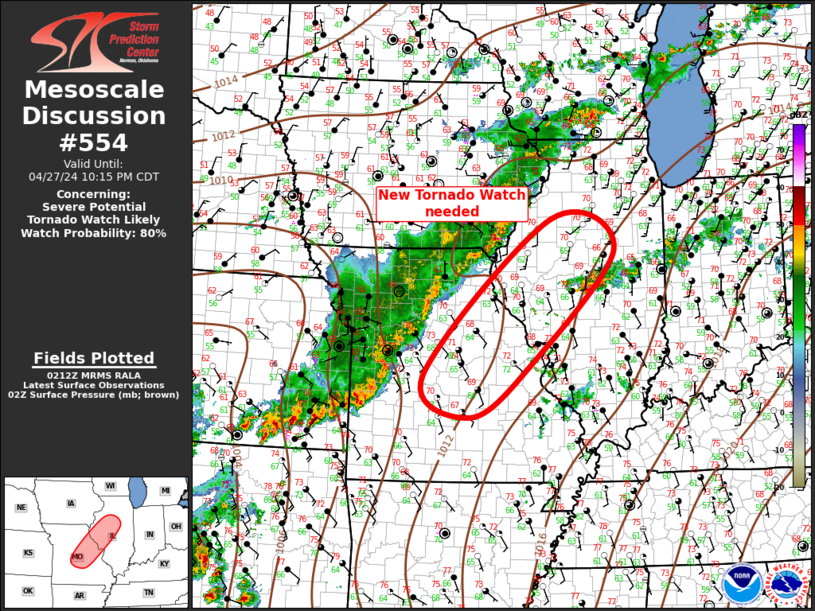
Mesoscale Discussion 0554
NWS Storm Prediction Center Norman OK
0915 PM CDT Sat Apr 27 2024

Areas affected...Middle Mississippi Valley

Concerning...Severe potential...Tornado Watch likely

Valid 280215Z - 280315Z

Probability of Watch Issuance...80 percent

SUMMARY...Severe risk will increase across central MO into central
IL late this evening into the early-morning hours. Tornado Watch is
warranted to account for this risk.

DISCUSSION...Strong low-level warm advection is noted across MO late
this evening as LLJ strengthens into this portion of the mid MS
Valley. An elongated LEWP extends from southeast KS-western/northern
MO-southeast IA. This MCS is gradually advancing east within a
strongly sheared, and modestly unstable air mass. 00z soundings from
SGF and ILX exhibited surface-6km bulk shear around 35kt, but 0-3
SRH is quite strong at SGF, and should strengthen a bit over the
next several hours. While the primary storm mode should remain a
LEWP, some risk for QLCS tornadoes will exist, along with embedded
supercells. New tornado watch will be issued given the current
trends.

..Darrow/Smith.. 04/28/2024

...Please see www.spc.noaa.gov for graphic product...

ATTN...WFO...ILX...LSX...DVN...SGF...EAX...

LAT...LON   38359300 41109013 40568868 38579056 37629192 38359300
Read more
SPC MD 553
MD 0553 CONCERNING SEVERE POTENTIAL...WATCH POSSIBLE FOR NORTHERN AND CENTRAL LOWER MICHIGAN
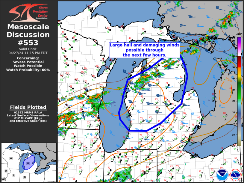
Mesoscale Discussion 0553
NWS Storm Prediction Center Norman OK
0840 PM CDT Sat Apr 27 2024

Areas affected...Northern and central Lower Michigan

Concerning...Severe potential...Watch possible

Valid 280140Z - 280315Z

Probability of Watch Issuance...60 percent

SUMMARY...Large hail and damaging winds possible with thunderstorms
through the evening and early morning.

DISCUSSION...Thunderstorms have been ongoing along a frontal
boundary extending across the northern Lower Michigan with reports
of hail up to penny size. This activity is likely to continue along
the boundary, with potential for the boundary to shift southward
through the evening/morning. Large hail and damaging winds will
likely be the main threats, given steep lapse rates and MLCAPE
around 1000 J/kg. A watch will be considered for portions of the
discussion area based on convective trends.

..Thornton/Smith.. 04/28/2024

...Please see www.spc.noaa.gov for graphic product...

ATTN...WFO...DTX...APX...GRR...

LAT...LON   44448638 44868525 45458415 45398353 44948327 44578315
            43518351 43108413 42788458 42478535 42478626 42908673
            43168682 43558665 43798662 44448638
Read more
SPC MD 552
MD 0552 CONCERNING TORNADO WATCH 149... FOR SOUTHEAST KS/WESTERN MO
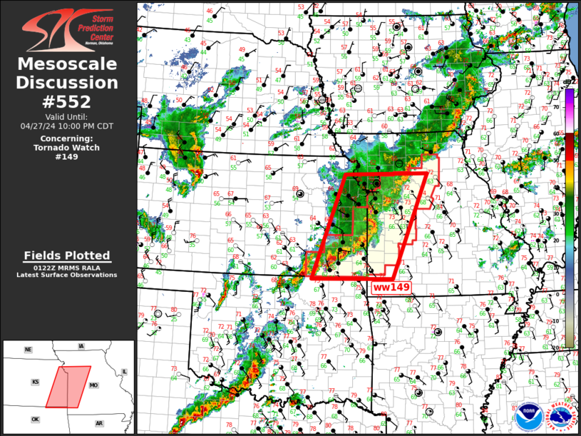
Mesoscale Discussion 0552
NWS Storm Prediction Center Norman OK
0825 PM CDT Sat Apr 27 2024
Areas affected...Southeast KS/western MO
Concerning...Tornado Watch 149...
Valid 280125Z - 280300Z
The severe weather threat for Tornado Watch 149 continues.
SUMMARY...Severe threat will gradually spread into eastern/southern
portions of ww149.
DISCUSSION...Slow-moving MCS has developed over eastern KS/western
MO early this evening. A weak MCV may ultimately evolve within this
complex near KMKC as an arcing band of convection is beginning to
surge east across Bates/Vernon County MO. Damaging wind threat may
increase ahead of this portion of the squall line. More discrete
supercells trail along the southwestern flank of the MCS across
southeast KS. As LLJ strengthens this evening, this activity should
continue propagating slowly northeast into southwest MO. Tornado
risk is highest with this southern flank activity.
..Darrow.. 04/28/2024
...Please see www.spc.noaa.gov for graphic product...
ATTN...WFO...SGF...EAX...TSA...TOP...ICT...
LAT...LON 36949634 39549531 39569269 36939380 36949634
Read more